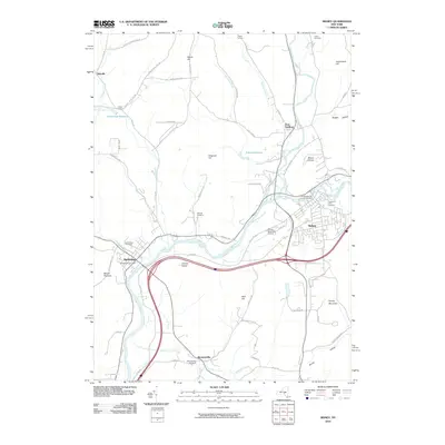
2010 Map of Sidney
USGS Topo · Published 2010About this map
The confluence of the Unadilla River and the Susquehanna River anchors this landscape in south-central New York, where the river valleys have long dictated the development of the region's main population centers. Modern Sidney and Bainbridge occupy the fertile floodplains, while the surrounding terrain is defined by prominent elevations such as Dingman Hill and Sidney Mountain. A network of smaller hamlets, including Bennettsville and Yaleville, are connected by local routes like Co Rd 38 and Yaleville-Hucklebom Rd.
Find a feature on this map
71 named features on this map. Tap any name to fly to it.
Don’t see what you’re looking for? This feature index may not catch every label — zoom into the map to look around manually.
Map Details
Editions of this 2010 Sidney Map
This is the sole edition of this map. No revisions or reprints were ever made.
Other maps of this area

1902 · Coventry
USGS Topo · 1:62,500

1904 · Oxford
USGS Topo · 1:62,500

1905 · Nineveh
USGS Topo · 1:62,500

1915 · Unadilla
USGS Topo · 1:62,500

1918 · Unadilla
USGS Topo · 1:62,500

1924 · Deposit
USGS Topo · 1:62,500

1926 · Deposit
USGS Topo · 1:62,500

1943 · Sidney
USGS Topo · 1:24,000

1943 · Gilbertsville
USGS Topo · 1:24,000
1943 · Unadilla
USGS Topo · 1:24,000