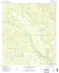
1978 Map of Sieper
USGS Topo · Published 1979About this map
The Calcasieu River meanders through the heart of the Kisatchie National Forest, creating a landscape defined by intricate creek systems and dense timberland on the border of Vernon and Rapides Parishes. Small communities like Sieper and Hineston anchor the region, connected by a network of forest roads and old railroad grades that speak to the area's history of logging. Genealogists will find significant value in the scattered rural cemeteries and churches, such as Pisgah Ch Cem and Hardshell Cem, which are tucked away near watercourses like Comrade Cr and Cypress Bayou. The presence of the Nichols Landing Strip near Leander and various pipeline corridors indicates the gradual modernization of this remote forest landscape by the late 1970s.
Find a feature on this map
34 named features on this map. Tap any name to fly to it.
Don’t see what you’re looking for? This feature index may not catch every label — zoom into the map to look around manually.
Map Details
Editions of this 1978 Sieper Map
This is the sole edition of this map. No revisions or reprints were ever made.
Other maps of this area

1932 · Boyce SW
USGS Topo · 1:31,680

1937 · Chopin SW
USGS Topo · 1:31,680

1937 · Chopin SE
USGS Topo · 1:31,680

1941 · Boyce
USGS Topo · 1:62,500

1943 · Leander
USGS Topo · 1:62,500

1944 · Chopin
USGS Topo · 1:62,500

1948 · Chopin
USGS Topo · 1:62,500

1953 · Alexandria
USGS Topo · 1:250,000
1954 · Leander
USGS Topo · 1:62,500
1954 · Temple
USGS Topo · 1:24,000