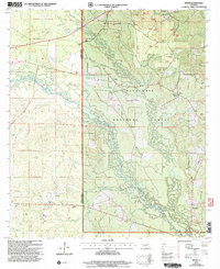
2003 Map of Sieper
USGS Topo · Published 2005About this map
Kisatchie National Forest dominates this landscape along the boundary of Vernon and Rapides Parishes, where the Calcasieu River and its numerous tributaries like Comrade Creek and Cypress Creek define the drainage patterns of central Louisiana. This 2003 revision reflects a region shaped by its watercourses and timberlands, with small communities such as Sieper, Stille, and Hineston linked by secondary roads and local crossings. The map reveals a high density of rural religious and funerary sites, including Pisgah Ch Cem and Hardshell Cem, which suggest long-standing family settlements within the forest. Notable landmarks such as Clifton Crossing, Price Crossing, and the Nichols Landing Strip indicate how residents have historically navigated this densely wooded and creek-carved terrain, while several churches like St Jude Ch and Leander Ch serve as central community hubs for the surrounding homesteads.
Find a feature on this map
42 named features on this map. Tap any name to fly to it.
Don’t see what you’re looking for? This feature index may not catch every label — zoom into the map to look around manually.
Map Details
Editions of this 2003 Sieper Map
This is the sole edition of this map. No revisions or reprints were ever made.
Other maps of this area

1932 · Boyce SW
USGS Topo · 1:31,680

1937 · Chopin SW
USGS Topo · 1:31,680

1937 · Chopin SE
USGS Topo · 1:31,680

1941 · Boyce
USGS Topo · 1:62,500

1943 · Leander
USGS Topo · 1:62,500

1944 · Chopin
USGS Topo · 1:62,500

1948 · Chopin
USGS Topo · 1:62,500

1953 · Alexandria
USGS Topo · 1:250,000
1954 · Leander
USGS Topo · 1:62,500
1954 · Temple
USGS Topo · 1:24,000