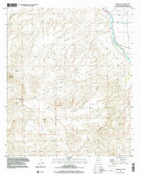
1996 Map of Sierra Alta
USGS Topo · Published 2001About this map
Rio Grande waters dominate the eastern edge of this landscape, cutting through the Rincon Valley where the river is accompanied by irrigation infrastructure like the Rincon Lateral and the Rincon Private Drain. This area reflects a mid-century ranching and transit corridor, highlighted by the Tonuco Bridge crossing and various established family holdings such as the Haynor Ranch and Hermitano Springs Ranch. To the west, the terrain rises sharply into the high ground of Sierra Alta and Sierra Kemado, dissected by numerous dry washes including Broad Canyon and Angostura Arroyo. The presence of scattered tanks like Hatchler Tank and Brewster Tank illustrates the critical role of water management in sustaining livestock across this arid New Mexico interior. For those tracing local history, the map includes details such as a Mine and a small Cem near the river valley.
Find a feature on this map
35 named features on this map. Tap any name to fly to it.
Don’t see what you’re looking for? This feature index may not catch every label — zoom into the map to look around manually.
Map Details
Editions of this 1996 Sierra Alta Map
This is the sole edition of this map. No revisions or reprints were ever made.
Other maps of this area

1891 · Las Cruces
USGS Topo · 1:125,000

1893 · Las Cruces
USGS Topo · 1:125,000

1916 · Tonuco
USGS Topo · 1:125,000

1932 · Tonuco
USGS Topo · 1:125,000

1941 · Las Cruces
USGS Topo · 1:62,500

1943 · Corralitos Ranch
USGS Topo · 1:62,500

1943 · Las Cruces
USGS Topo · 1:62,500

1948 · San Diego Mountain
USGS Topo · 1:62,500

1955 · Las Cruces
USGS Topo · 1:250,000

1958 · Las Cruces
USGS Topo · 1:250,000