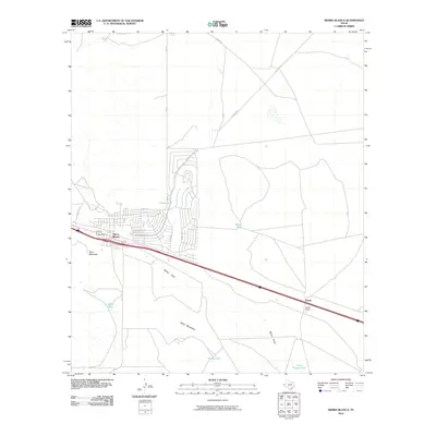
2010 Map of Sierra Blanca
USGS Topo · Published 2010About this map
Sierra Blanca serves as the primary hub of activity in this West Texas landscape, showing a grid of residential streets like Cortez St and Sunset Rd near the major transportation corridors. The town is situated in a basin-like environment, flanked by prominent elevations such as Texan Mountain to the west and Sand Mountain to the south. A network of ranch roads, including Pasture Rd and Big Tank Rd, extends into the surrounding arid terrain, connecting remote points like Faskin Ranch and the settlement of Arispe.
Find a feature on this map
23 named features on this map. Tap any name to fly to it.
Don’t see what you’re looking for? This feature index may not catch every label — zoom into the map to look around manually.
Map Details
Editions of this 2010 Sierra Blanca Map
This is the sole edition of this map. No revisions or reprints were ever made.
Other maps of this area

1895 · Sierra Blanca
USGS Topo · 1:125,000

1948 · Triple Hill
USGS Topo · 1:62,500

1954 · Van Horn
USGS Topo · 1:250,000

1958 · Van Horn
USGS Topo · 1:250,000
1963 · Grayton Lake
USGS Topo · 1:24,000

1964 · Devil Ridge
USGS Topo · 1:24,000

1964 · Dome Peak
USGS Topo · 1:24,000

1964 · Lasca
USGS Topo · 1:24,000

1964 · Sierra Blanca SW
USGS Topo · 1:24,000
1964 · Sierra Blanca
USGS Topo · 1:24,000