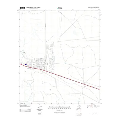
2013 Map of Sierra Blanca
USGS Topo · Published 2013About this map
Sierra Blanca serves as a vital transit hub in the high desert of Hudspeth County, where the street grid expands north of the primary transportation corridor. The town layout is detailed with specific residential thoroughfares such as Sierra Blanca Dr and Rio Grande Blvd. This area is characterized by its ranching infrastructure and desert landmarks, including Texan Mtn and Sand Mtn. To the southeast, the small settlement of Arispe and the nearby Faskin Ranch sit along the major transit line, while the surrounding landscape is marked by numerous water catchments essential for local livestock, such as Blount Tank, Corner Tank, and Cross Tracks Tank. The map also traces the path of Ranch Road 1111 as it intersects the high-desert terrain near Stray Tank.
Find a feature on this map
42 named features on this map. Tap any name to fly to it.
Don’t see what you’re looking for? This feature index may not catch every label — zoom into the map to look around manually.
Map Details
Editions of this 2013 Sierra Blanca Map
This is the sole edition of this map. No revisions or reprints were ever made.
Other maps of this area

1895 · Sierra Blanca
USGS Topo · 1:125,000

1948 · Triple Hill
USGS Topo · 1:62,500

1954 · Van Horn
USGS Topo · 1:250,000

1958 · Van Horn
USGS Topo · 1:250,000
1963 · Grayton Lake
USGS Topo · 1:24,000

1964 · Devil Ridge
USGS Topo · 1:24,000

1964 · Dome Peak
USGS Topo · 1:24,000

1964 · Lasca
USGS Topo · 1:24,000

1964 · Sierra Blanca SW
USGS Topo · 1:24,000
1964 · Sierra Blanca
USGS Topo · 1:24,000