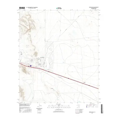
2016 Map of Sierra Blanca
USGS Topo · Published 2016About this map
Sierra Blanca serves as the focal point of this Trans-Pecos landscape, situated at the junction of Interstate 10 and Ranch Rd 1111. The town's grid is clearly defined, with streets like Rio Grande Blvd, Santa Fe Blvd, and Juarez Blvd reflecting the regional heritage and transportation significance. To the southeast, the small settlement of Arispe sits along the Guadalupe Mountain Ter corridor, highlighting the historical transit routes through this arid environment.
Find a feature on this map
37 named features on this map. Tap any name to fly to it.
Don’t see what you’re looking for? This feature index may not catch every label — zoom into the map to look around manually.
Map Details
Editions of this 2016 Sierra Blanca Map
This is the sole edition of this map. No revisions or reprints were ever made.
Other maps of this area

1895 · Sierra Blanca
USGS Topo · 1:125,000

1948 · Triple Hill
USGS Topo · 1:62,500

1954 · Van Horn
USGS Topo · 1:250,000

1958 · Van Horn
USGS Topo · 1:250,000
1963 · Grayton Lake
USGS Topo · 1:24,000

1964 · Devil Ridge
USGS Topo · 1:24,000

1964 · Dome Peak
USGS Topo · 1:24,000

1964 · Lasca
USGS Topo · 1:24,000

1964 · Sierra Blanca SW
USGS Topo · 1:24,000
1964 · Sierra Blanca
USGS Topo · 1:24,000