
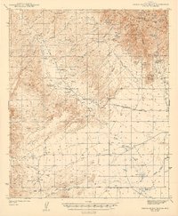
1943 Map of Sierra Bonita Ranch
USGS Topo · Published 1943About this map
High desert cattle operations and remote mountain outposts define this 1940s landscape, anchored by the legendary Sierra Bonita Ranch and the Eureka Ranch. The terrain transitions from the heights of the Graham Mountains, home to the West Peak lookout and the Goldbug Tunnel, down into the Sulphur Spring Valley. Evidence of early livestock management and water rights is scattered throughout the drainages, including the Hooker Cienega and numerous labeled water improvements like Mesa Windmill and Crack Tank. Local education and community life are represented by the solitary Sunset School, while the presence of the Shotgun Smith Ranch and K H Ranch—both noted as abandoned—hints at the era's shifting settlement patterns. The geography is further marked by the Bonita Aravaipa Road and the President Mine, reflecting a dual economy of ranching and early mineral extraction.
Find a feature on this map
49 named features on this map. Tap any name to fly to it.
Don’t see what you’re looking for? This feature index may not catch every label — zoom into the map to look around manually.
Map Details
Editions of this 1943 Sierra Bonita Ranch Map
2 editions found
Other maps of this area

1922 · Willcox
USGS Topo · 1:125,000

1938 · Galiuro Mts
USGS Topo · 1:48,000

1938 · Klondyke
USGS Topo · 1:48,000

1940 · Sierra Bonita Ranch
USGS Topo · 1:62,500

1942 · Sierra Bonita Ranch
USGS Topo · 1:62,500

1942 · Mt. Graham
USGS Topo · 1:62,500

1943 · Willcox
USGS Topo · 1:62,500

1943 · Galiuro Mts
USGS Topo · 1:62,500

1943 · Klondyke
USGS Topo · 1:62,500

1943 · Winchester Mts.
USGS Topo · 1:62,500