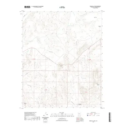
2020 Map of Sierra De La Cruz
USGS Topo · Published 2020About this map
Sierra de la Cruz rises as the central landmark in this portion of Socorro County, anchoring a landscape defined by complex drainage networks and arid landforms. The terrain transitions from the high, flat profile of Black Mesa and the steep walls of Palo Duro Canyon in the northeast to a series of intricate arroyos and canyons. Significant water management for livestock or wildlife is evident through the placement of Dennis Tank and Valle de Adrian Tank, while natural water sources like Cibola Spring suggest historic points of importance in this dry environment. The mapping of Arroyo Milagro and Arroyo de Alamillo highlights the erosion patterns typical of the region. This modern survey also preserves family or local names associated with the topography, such as Cuesta de la McBride and the narrow passes of Cañoncito Colorado and Cañoncito de la Uva.
Find a feature on this map
23 named features on this map. Tap any name to fly to it.
Don’t see what you’re looking for? This feature index may not catch every label — zoom into the map to look around manually.
Map Details
Editions of this 2020 Sierra De La Cruz Map
This is the sole edition of this map. No revisions or reprints were ever made.
Other maps of this area

1906 · Socorro
USGS Topo · 1:62,500

1916 · La Joya
USGS Topo · 1:125,000

1952 · La Joya
USGS Topo · 1:24,000

1952 · Becker SW
USGS Topo · 1:24,000

1952 · Cerro Montoso
USGS Topo · 1:24,000

1954 · Socorro
USGS Topo · 1:250,000

1958 · Socorro
USGS Topo · 1:250,000

1959 · Loma De Las Canas
USGS Topo · 1:24,000

1959 · Mesa Del Yeso
USGS Topo · 1:24,000

1959 · Socorro
USGS Topo · 1:62,500