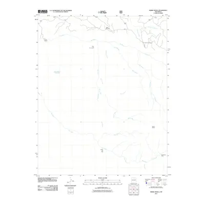
2011 Map of Sierra Mosca
USGS Topo · Published 2011About this map
Sierra Mosca rises above a landscape defined by an intricate network of drainages and high mesa terrain in this 2011 survey of the Santa Fe National Forest area. The map documents a rugged interior characterized by the deep incisions of Rio Medio, Rio Frijoles, and Rio Molino. Mining history is represented by the Santa Rita Beryl Prospect situated near Cañada de Amole, while recreational and resource management is evidenced by the Borrego Mesa Campground and the Sierra Mosca Trick Tank. The complex hydrography includes numerous seasonal and perennial flows such as Rito con Agua and Rito sin Agua, illustrating the hydrological patterns of this high-elevation region. The survey also captures the convergence of various Forest Service routes, including road 306 and 306a, which provide access to Mesa Borrego and other points within the surrounding forest.
Find a feature on this map
25 named features on this map. Tap any name to fly to it.
Don’t see what you’re looking for? This feature index may not catch every label — zoom into the map to look around manually.
Map Details
Editions of this 2011 Sierra Mosca Map
This is the sole edition of this map. No revisions or reprints were ever made.
Other maps of this area

1889 · Santa Fe
USGS Topo · 1:125,000

1894 · Santa Fe
USGS Topo · 1:125,000

1953 · Tesuque
USGS Topo · 1:24,000

1953 · Truchas
USGS Topo · 1:24,000

1953 · Sierra Mosca
USGS Topo · 1:24,000
1953 · Cundiyo
USGS Topo · 1:24,000

1953 · Chimayo
USGS Topo · 1:24,000

1953 · Aspen Basin
USGS Topo · 1:24,000

1954 · Santa Fe
USGS Topo · 1:250,000

1954 · Raton
USGS Topo · 1:250,000