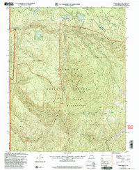
2002 Map of Sierra Mosca
USGS Topo · Published 2003About this map
Santo Domingo de Cundiyo Grant and the Nambe Indian Res meet along the western boundary of this high-elevation mountain terrain within the Santa Fe National Forest. The landscape is defined by the sharp transition between the broad, flat profiles of Mesa Borrego and the deep, winding incisions of Cañon Navajo and Cañon Chimayo. These canyons channel several significant waterways, including the Rio Medio and Rio Quemado, which flow through the protected reaches of the Pecos Wilderness. The presence of the Borrego Trail and scattered high-altitude springs like Cienega Redondo reflect the area's historical reliance on seasonal grazing paths and primitive routes through the Santa Fe Mountains. This survey captures the region's wilderness character just after the turn of the millennium, documenting the hydrography and topography of the New Mexico backcountry before modern shifts in forest management.
Find a feature on this map
29 named features on this map. Tap any name to fly to it.
Don’t see what you’re looking for? This feature index may not catch every label — zoom into the map to look around manually.
Map Details
Editions of this 2002 Sierra Mosca Map
This is the sole edition of this map. No revisions or reprints were ever made.
Other maps of this area

1889 · Santa Fe
USGS Topo · 1:125,000

1894 · Santa Fe
USGS Topo · 1:125,000

1953 · Tesuque
USGS Topo · 1:24,000

1953 · Truchas
USGS Topo · 1:24,000

1953 · Sierra Mosca
USGS Topo · 1:24,000
1953 · Cundiyo
USGS Topo · 1:24,000

1953 · Chimayo
USGS Topo · 1:24,000

1953 · Aspen Basin
USGS Topo · 1:24,000

1954 · Santa Fe
USGS Topo · 1:250,000

1954 · Raton
USGS Topo · 1:250,000