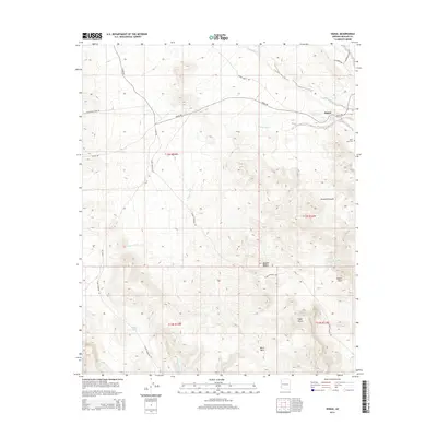
2014 Map of Signal
USGS Topo · Published 2014About this map
The settlement of Signal sits along the northern edge of the Mojave Desert in Mohave County, where the desert floor transitions into the elevated terrain of Black Mesa and the Chuckwalla Hills. This 2014 survey captures a landscape defined by seasonal watercourses and mining access, featuring the Signal Area Cem and Signal Spring near the primary townsite. The local geography is etched by prominent drainages like Graveyard Wash, Rupley Wash, and Madril Wash, which navigate the complex topography around Madril Peak and Eagle Point. The transportation network is built for rugged utility, anchored by Signal Rd, McCracken Mine Rd, and Alamo Crossing Rd, reflecting the area's history of mineral extraction and remote desert transit. Isolated water sources like Maggie Tank further emphasize the arid character of this high-desert environment.
Find a feature on this map
24 named features on this map. Tap any name to fly to it.
Don’t see what you’re looking for? This feature index may not catch every label — zoom into the map to look around manually.
Map Details
Editions of this 2014 Signal Map
This is the sole edition of this map. No revisions or reprints were ever made.
Other maps of this area

1923 · Signal
USGS Topo · 1:250,000

1942 · Signal
USGS Topo · 1:250,000

1950 · Prescott
USGS Topo · 1:250,000

1954 · Prescott
USGS Topo · 1:250,000

1958 · Prescott
USGS Topo · 1:250,000

1959 · Prescott
USGS Topo · 1:250,000

1960 · Prescott
USGS Topo · 1:250,000

1965 · Prescott
USGS Topo · 1:250,000
1966 · Castaneda Hills
USGS Topo · 1:62,500

1966 · Artillery Peak
USGS Topo · 1:62,500