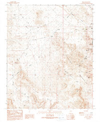
1990 Map of Signal
USGS Topo · Published 1990About this map
The desert landscape of Mohave County reveals a history of extraction and survival near Rupley at the close of the 20th century. High elevations like Black Mesa and Madril Peak overlook a network of mining activity centered around the Artillery Mountains. This map documents numerous resource-gathering points, from the Goldbug Mine and multiple Adits to vital desert water sources such as Signal Spring, Maggie Tank, and Rupley Well.
Find a feature on this map
33 named features on this map. Tap any name to fly to it.
Don’t see what you’re looking for? This feature index may not catch every label — zoom into the map to look around manually.
Map Details
Editions of this 1990 Signal Map
This is the sole edition of this map. No revisions or reprints were ever made.
Other maps of this area

1923 · Signal
USGS Topo · 1:250,000

1942 · Signal
USGS Topo · 1:250,000

1950 · Prescott
USGS Topo · 1:250,000

1954 · Prescott
USGS Topo · 1:250,000

1958 · Prescott
USGS Topo · 1:250,000

1959 · Prescott
USGS Topo · 1:250,000

1960 · Prescott
USGS Topo · 1:250,000

1965 · Prescott
USGS Topo · 1:250,000
1966 · Castaneda Hills
USGS Topo · 1:62,500

1966 · Artillery Peak
USGS Topo · 1:62,500