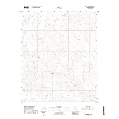
2018 Map of Signal Mountain
USGS Topo · Published 2018About this map
The Big Sandy River defines the western corridor of this desert landscape, where the Signal Area Cem stands as a quiet marker of local history near the river's edge. Rising prominently from the center of the sheet, Signal Mtn serves as a natural landmark overlooking the northern reaches of the Mojave Desert. The terrain transitions into the high ridges of the Artillery Mountains to the south, cut by deep drainages like Arrastra Canyon and Hackberry Canyon. This arid environment is punctuated by vital water sources such as Alamo Spring, Cattail Spring, and Chino Spring, which have historically dictated travel and survival in the region. Local access is provided by unpaved routes like Alamo Rd and Signal Rd, reflecting the remote and sparsely settled nature of this part of Mohave County.
Find a feature on this map
22 named features on this map. Tap any name to fly to it.
Don’t see what you’re looking for? This feature index may not catch every label — zoom into the map to look around manually.
Map Details
Editions of this 2018 Signal Mountain Map
This is the sole edition of this map. No revisions or reprints were ever made.
Other maps of this area

1923 · Signal
USGS Topo · 1:250,000

1942 · Signal
USGS Topo · 1:250,000

1950 · Prescott
USGS Topo · 1:250,000

1954 · Prescott
USGS Topo · 1:250,000

1958 · Prescott
USGS Topo · 1:250,000

1959 · Prescott
USGS Topo · 1:250,000

1960 · Prescott
USGS Topo · 1:250,000

1965 · Prescott
USGS Topo · 1:250,000

1966 · Artillery Peak
USGS Topo · 1:62,500
1967 · Groom Spring
USGS Topo · 1:24,000