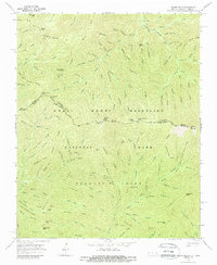
1964 Map of Silers Bald
USGS Topo · Published 1988About this map
Great Smoky Mountains National Park straddles the high ridges along the state line in this mid-1960s survey. The landscape is defined by the sharp divide of the Appalachian Trail, which follows the boundary between Sevier and Swain Counties. Water sources like Dripping Spring and the Moss Hollow River feed numerous prongs and branches that carve deep into the terrain, such as Lynn Camp Prong and Goshen Prong. Local nomenclature reflects the difficult topography and early human presence, seen in names like Mellinger Death Ridge, Seng Patch, and Ben Parton Lookout. This map documents a wilderness area largely devoid of permanent settlements, focused instead on the network of gaps and balds like Bearwallow Bald and Jakes Gap that once served as crucial passage points for travelers and residents of the high Smokies before the area's designation as a national park.
Find a feature on this map
113 named features on this map. Tap any name to fly to it.
Don’t see what you’re looking for? This feature index may not catch every label — zoom into the map to look around manually.
Map Details
Editions of this 1964 Silers Bald Map
3 editions found
Other maps of this area

1886 · Knoxville
USGS Topo · 1:125,000

1891 · Cowee
USGS Topo · 1:125,000

1892 · Knoxville
USGS Topo · 1:125,000

1893 · Mt Guyot
USGS Topo · 1:125,000

1894 · Knoxville
USGS Topo · 1:125,000

1895 · Knoxville
USGS Topo · 1:125,000

1897 · Cowee
USGS Topo · 1:125,000

1901 · Knoxville
USGS Topo · 1:125,000

1907 · Cowee
USGS Topo · 1:125,000

1912 · Mt Guyot
USGS Topo · 1:125,000