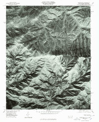
1976 Map of Silers Bald
USGS Topo · Published 1978About this map
Silers Bald serves as the central high point of this high-elevation terrain, where several major mountain spines converge in the mid-1970s. This orthophotoquad provides an aerial perspective of the dense forest cover and steep topography that defines the border region between North Carolina and Tennessee. The map illustrates the complex drainage patterns established by the radiating spurs, including Goshen Ridge and Proctor Ridge.
Find a feature on this map
6 named features on this map. Tap any name to fly to it.
Don’t see what you’re looking for? This feature index may not catch every label — zoom into the map to look around manually.
Map Details
Editions of this 1976 Silers Bald Map
This is the sole edition of this map. No revisions or reprints were ever made.
Other maps of this area

1886 · Knoxville
USGS Topo · 1:125,000

1891 · Cowee
USGS Topo · 1:125,000

1892 · Knoxville
USGS Topo · 1:125,000

1893 · Mt Guyot
USGS Topo · 1:125,000

1894 · Knoxville
USGS Topo · 1:125,000

1895 · Knoxville
USGS Topo · 1:125,000

1897 · Cowee
USGS Topo · 1:125,000

1901 · Knoxville
USGS Topo · 1:125,000

1907 · Cowee
USGS Topo · 1:125,000

1912 · Mt Guyot
USGS Topo · 1:125,000