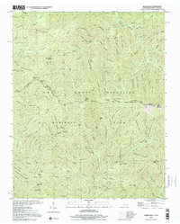
2000 Map of Silers Bald
USGS Topo · Published 2001About this map
Great Smoky Mountains National Park straddles the high ridges of the Tennessee and North Carolina border on this late-twentieth-century survey. The landscape is defined by the steep drainage basins of the Little River and Goshen Prong, where numerous branches like Monteith Branch and Fish Camp Prong carve through the deep hollows. The Appalachian National Scenic Trail follows the highest elevations along the state line, crossing prominent landmarks such as Silers Bald, Mt Buckley, and the precarious stretch known as The Narrows. This map illustrates the primitive infrastructure of the backcountry, including the Bridle Path and remote locations like Cascades Campsite. From the Ben Parton Lookout to Buckhorn Bald, the topography reveals a wilderness managed for conservation, where the labels of numerous gaps and knobs document the local nomenclature of this high-altitude terrain.
Find a feature on this map
116 named features on this map. Tap any name to fly to it.
Don’t see what you’re looking for? This feature index may not catch every label — zoom into the map to look around manually.
Map Details
Editions of this 2000 Silers Bald Map
This is the sole edition of this map. No revisions or reprints were ever made.
Other maps of this area

1886 · Knoxville
USGS Topo · 1:125,000

1891 · Cowee
USGS Topo · 1:125,000

1892 · Knoxville
USGS Topo · 1:125,000

1893 · Mt Guyot
USGS Topo · 1:125,000

1894 · Knoxville
USGS Topo · 1:125,000

1895 · Knoxville
USGS Topo · 1:125,000

1897 · Cowee
USGS Topo · 1:125,000

1901 · Knoxville
USGS Topo · 1:125,000

1907 · Cowee
USGS Topo · 1:125,000

1912 · Mt Guyot
USGS Topo · 1:125,000