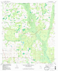
1994 Map of Sills
USGS Topo · Published 1998About this map
The Chipola River corridor defines the eastern reaches of this Jackson County landscape, where the state line meets Alabama. The terrain is characterized by a dense network of water bodies and marshlands, including Marshall Creek, Anderson Lake, and the expansive Pittman Bay. Small rural communities and congregations are scattered throughout the pine-dotted lowlands, evidenced by numerous country churches such as Holyneck Ch, St Phillips Ch, and Ephesus Ch. Near the southern border, Waddells Mill Pond stands as a notable landmark of local industry and water management. Genealogists will find particular value in the identification of family-named sites like Moulten Cem and the Hart Cem, reflecting the deep-rooted settlement patterns of the Sills area during the late twentieth century.
Find a feature on this map
36 named features on this map. Tap any name to fly to it.
Don’t see what you’re looking for? This feature index may not catch every label — zoom into the map to look around manually.
Map Details
Editions of this 1994 Sills Map
This is the sole edition of this map. No revisions or reprints were ever made.
Other maps of this area

1952 · Cottondale East
USGS Topo · 1:24,000

1952 · Malone
USGS Topo · 1:24,000

1952 · Campbellton
USGS Topo · 1:24,000

1952 · Cottondale West
USGS Topo · 1:24,000

1952 · Sills
USGS Topo · 1:24,000

1952 · Marianna
USGS Topo · 1:24,000

1953 · Dothan
USGS Topo · 1:250,000

1954 · Dothan
USGS Topo · 1:250,000

1954 · Tallahassee
USGS Topo · 1:250,000

1955 · Dothan
USGS Topo · 1:250,000