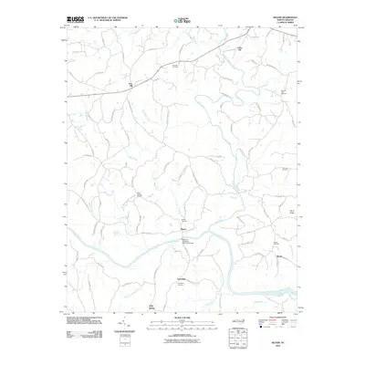
2010 Map of Siloam
USGS Topo · Published 2010About this map
The Ararat River carves a winding path through this North Carolina landscape before its confluence with the Yadkin River, defining the rural character of communities like Siloam and Shoals. In 2010, the region remains defined by its agricultural roots and ancestral geography, anchored by a high concentration of local burial grounds including Siloam Cemetery and Friendship Cemetery. Significant river crossings and infrastructure are noted at the Atkinson-Needham Memorial Bridge and along Pilot Power Dam Rd, reflecting the area's historical reliance on these waterways for transit and power. To the east, the elevation rises toward Stony Ridge, while smaller water bodies like Skin Cabin Creek and Candiff Creek drain the surrounding hills. Genealogists will find many family-linked paths, such as Stevenson Farm Ln and Crissman Rd, which reveal the deep settlement patterns of Yadkin County.
Find a feature on this map
87 named features on this map. Tap any name to fly to it.
Don’t see what you’re looking for? This feature index may not catch every label — zoom into the map to look around manually.
Map Details
Editions of this 2010 Siloam Map
This is the sole edition of this map. No revisions or reprints were ever made.
Other maps of this area

1891 · Yadkinville
USGS Topo · 1:125,000

1893 · Yadkinville
USGS Topo · 1:125,000

1953 · Winston-Salem
USGS Topo · 1:250,000

1955 · Winston-Salem
USGS Topo · 1:250,000

1962 · Winston-Salem
USGS Topo · 1:250,000

1964 · Pinnacle
USGS Topo · 1:24,000

1964 · Pilot Mountain
USGS Topo · 1:24,000

1966 · Yadkinville
USGS Topo · 1:24,000

1966 · East Bend
USGS Topo · 1:24,000
1968 · Vienna
USGS Topo · 1:24,000