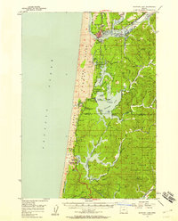
1956 Map of Siltcoos Lake
USGS Topo · Published 1958About this map
The Siuslaw River and its complex network of sloughs define this mid-century coastal landscape, where the Oregon Dunes meet a series of large freshwater lakes. Around Florence and Glenada, the map illustrates a transition from maritime activity to timber and rail transport. The Southern Pacific railroad follows the riverbank through Cushman before striking south toward Siltcoos and Westlake, serving a region where water and rail were the primary lifelines for small outposts like Canary and Ada.
Find a feature on this map
66 named features on this map. Tap any name to fly to it.
Don’t see what you’re looking for? This feature index may not catch every label — zoom into the map to look around manually.
Map Details
Editions of this 1956 Siltcoos Lake Map
3 editions found
Other maps of this area

1918 · Mapleton
USGS Topo · 1:48,000

1919 · Earl
USGS Topo · 1:48,000

1920 · Siltcoos Lake
USGS Topo · 1:62,500

1920 · Heceta Head
USGS Topo · 1:62,500

1923 · Reedsport
USGS Topo · 1:62,500

1940 · Mapleton
USGS Topo · 1:62,500

1941 · Siltcoos Lake
USGS Topo · 1:62,500

1942 · Heceta Head
USGS Topo · 1:62,500

1942 · Siltcoos Lake
USGS Topo · 1:62,500

1942 · Reedsport
USGS Topo · 1:62,500