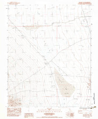
1983 Map of Silurian Lake
USGS Topo · Published 1983About this map
Silurian Lake dominates this arid landscape in the early 1980s, serving as the central topographical focus of the Silurian Valley. The map documents the persistent traces of human activity in the Mojave Desert, most notably at the Renoville (Site) and further south at Renoville, marking the locations of former settlements. The drainage patterns of Kingston Wash and Salt Creek illustrate the hydrologic character of this basin-and-range province, where water flow is intermittent and primarily subterranean toward the dry lake bed.
Find a feature on this map
16 named features on this map. Tap any name to fly to it.
Don’t see what you’re looking for? This feature index may not catch every label — zoom into the map to look around manually.
Map Details
Editions of this 1983 Silurian Lake Map
This is the sole edition of this map. No revisions or reprints were ever made.
Other maps of this area

1933 · Avawatz Mountains
USGS Topo · 1:250,000

1947 · Trona
USGS Topo · 1:250,000

1948 · Red Pass Lake
USGS Topo · 1:62,500

1948 · Trona
USGS Topo · 1:250,000

1948 · Avawatz Pass
USGS Topo · 1:62,500

1951 · Avawatz Pass
USGS Topo · 1:62,500

1951 · Red Pass Lake
USGS Topo · 1:62,500

1953 · Trona
USGS Topo · 1:250,000

1956 · Silurian Hills
USGS Topo · 1:62,500

1956 · Baker
USGS Topo · 1:62,500