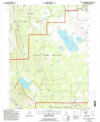
1993 Map of Silva Flat Reservoir
USGS Topo · Published 1996About this map
High-altitude water management and livestock grazing define this corner of the California back country during the late twentieth century. Spanning the boundary of Modoc County and Lassen County, the landscape is dotted with small-scale reservoirs and waterholes essential for maintaining life in the high desert terrain of the Modoc National Forest. Prominent water features like the Silva Flat Reservoir and Coyote Reservoir are joined by numerous smaller catchments, such as Deadhorse Reservoir and Bold Ridges Reservoir. In the northeast, the presence of Hayden Hill and its nearby Cem suggests the area's legacy of prospecting and small-scale settlement. Named springs like Brunselmeier Spring and Ollie Rivis Spring provide glimpses into the individuals who worked this land, while the State Game Refuge indicates the area's twentieth-century role in wildlife conservation.
Find a feature on this map
52 named features on this map. Tap any name to fly to it.
Don’t see what you’re looking for? This feature index may not catch every label — zoom into the map to look around manually.
Map Details
Editions of this 1993 Silva Flat Reservoir Map
This is the sole edition of this map. No revisions or reprints were ever made.
Other maps of this area

1886 · Alturas
USGS Topo · 1:250,000

1886 · Honey Lake
USGS Topo · 1:250,000

1886 · Lassen Peak
USGS Topo · 1:250,000

1886 · Modoc Lava Bed
USGS Topo · 1:250,000

1891 · Honey Lake
USGS Topo · 1:250,000

1892 · Modoc Lava-Bed
USGS Topo · 1:250,000

1892 · Lassen Peak
USGS Topo · 1:250,000

1892 · Alturas
USGS Topo · 1:250,000

1893 · Honey Lake
USGS Topo · 1:250,000

1894 · Lassen Peak
USGS Topo · 1:250,000