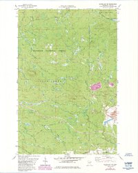
1982 Map of Silver Bay SW
USGS Topo · Published 1985About this map
Superior National Forest and Finland State Forest dominate this section of the Minnesota North Shore backcountry, where the landscape is defined by the complex drainage systems of the Beaver River and Split Rock River. In the early 1980s, industrial infrastructure began to leave a significant mark on this wooded terrain, most notably through the construction of the Milepost Seven Tailings Pond and its associated Mining Railroad Grade. These features illustrate the intersection of the region's taconite industry with the wilder stretches of the Arrowhead. Smaller scale landmarks like the Silver Bay Municipal Airport and a designated Snowmobile Trail highlight the transition between the working forest and local recreation. The map meticulously tracks the winding courses of Silver Creek and Thirtynine Creek, providing a detailed record of the hydrological network before subsequent land-use changes.
Find a feature on this map
15 named features on this map. Tap any name to fly to it.
Don’t see what you’re looking for? This feature index may not catch every label — zoom into the map to look around manually.
Map Details
Editions of this 1982 Silver Bay SW Map
2 editions found
Other maps of this area

1953 · Whyte
USGS Topo · 1:62,500

1954 · Silver Bay
USGS Topo · 1:62,500

1954 · Two Harbors
USGS Topo · 1:250,000

1956 · Split Rock Point
USGS Topo · 1:24,000

1956 · Split Rock Point
USGS Topo · 1:62,500

1956 · Split Rock Point NE
USGS Topo · 1:24,000

1957 · Two Harbors
USGS Topo · 1:250,000

1957 · Two Harbors
USGS Topo · 1:62,500

1957 · Two Harbors NE
USGS Topo · 1:24,000

1958 · Two Harbors
USGS Topo · 1:250,000