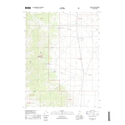
2018 Map of Silver Canyon
USGS Topo · Published 2018About this map
The Schell Creek Range dominates the western half of this Nevada landscape, where the rugged topography of the Humboldt National Forest meets the open expanse of Spring Valley. This high-desert terrain is marked by a series of dramatic canyons, including Silver Canyon, North Canyon, and Sanford Canyon, each carving through the range toward the valley floor. Water sources are critical identifiers in this arid environment, with several named springs such as Mud Springs, Osborne Springs, and Willow Spring providing vital points of reference. The map documents a landscape defined by ranching and resource access, evidenced by a network of local routes like the Spring Valley Creek Rd and White Pine Co Road 32. Higher elevations are characterized by features like Siegel Basin, while the eastern portion of the sheet transitions into the flatter basin-and-range geography typical of White Pine County.
Find a feature on this map
33 named features on this map. Tap any name to fly to it.
Don’t see what you’re looking for? This feature index may not catch every label — zoom into the map to look around manually.
Map Details
Editions of this 2018 Silver Canyon Map
This is the sole edition of this map. No revisions or reprints were ever made.
Other maps of this area

1956 · Ely
USGS Topo · 1:250,000

1959 · Ely
USGS Topo · 1:250,000

1963 · Ely
USGS Topo · 1:250,000
1982 · Kalamazoo Creek
USGS Topo · 1:24,000
1982 · Silver Canyon
USGS Topo · 1:24,000
1982 · Stonehouse
USGS Topo · 1:24,000
1982 · Schellbourne
USGS Topo · 1:24,000
1982 · Mattier Creek
USGS Topo · 1:24,000
1982 · Kalamazoo Summit
USGS Topo · 1:24,000
1986 · Big Hard Pan
USGS Topo · 1:24,000