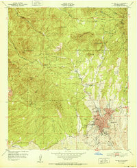
1951 Map of Silver City
USGS Topo · Published 1951About this map
Silver City anchors this 1951 topographic study, appearing as a developed mountain hub surrounded by the complex terrain of the Gila National Forest. The map documents a community deeply tied to its geography, where the street grid of the town site terminates abruptly against the rising slopes of Boston Hill and the former mining activity at Chloride Flat. Educational and social institutions are prominent, including the New Mexico Western College campus and St Marys Academy, alongside the Cottage Sanatorium north of the central district. The landscape is defined by the Continental Divide, which snakes through the high country past Bear Mountain and Gomez Peak. Traces of earlier industrial efforts are visible in the numerous abandoned quarries scattered near the town's western edge, providing a clear record of the area's mid-century transition from resource extraction toward its role as a regional center.
Find a feature on this map
36 named features on this map. Tap any name to fly to it.
Don’t see what you’re looking for? This feature index may not catch every label — zoom into the map to look around manually.
Map Details
Editions of this 1951 Silver City Map
This is the sole edition of this map. No revisions or reprints were ever made.
Other maps of this area

1909 · Silver City
USGS Topo · 1:125,000

1947 · Twin Sisters
USGS Topo · 1:24,000

1947 · Fort Bayard
USGS Topo · 1:24,000

1948 · Twin Sisters
USGS Topo · 1:24,000

1949 · Fort Bayard
USGS Topo · 1:24,000

1949 · Hurley West
USGS Topo · 1:24,000

1949 · Circle Mesa
USGS Topo · 1:24,000

1950 · Tyrone
USGS Topo · 1:24,000

1950 · Dorsey Ranch
USGS Topo · 1:24,000

1950 · Wind Mountain
USGS Topo · 1:24,000