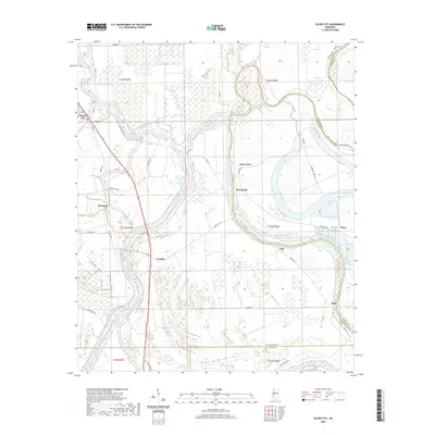
2020 Map of Silver City
USGS Topo · Published 2020About this map
The Yazoo River defines the landscape of this Humphreys County region, where flood control structures like the Will M Whittington Auxiliary Channel and extensive Levee systems protect the fertile delta lowlands. The town of Silver City sits at the intersection of Silver Creek and the river, serving as a focal point for the surrounding agricultural settlements of Richland, Lamkin, and Lodi. The mapping detail captures the complex hydrology of the area, featuring oxbow remnants like Tehula Lake and Bee Lake, which suggest the historic shifting of the river's course. Local history is preserved in the location of rural landmarks such as Pluto Cem near the community of Pluto and Jones Cem in the northeast. Small hamlets like Gum Grove, Roseneath, and Hidi are connected by a network of rural routes, including River Rd and Silver City Rd, illustrating the persistent rural character of this Mississippi Delta territory.
Find a feature on this map
50 named features on this map. Tap any name to fly to it.
Don’t see what you’re looking for? This feature index may not catch every label — zoom into the map to look around manually.
Map Details
Editions of this 2020 Silver City Map
This is the sole edition of this map. No revisions or reprints were ever made.
Other maps of this area

1940 · Auter
USGS Topo · 1:62,500

1940 · Mileston
USGS Topo · 1:62,500

1953 · Greenwood
USGS Topo · 1:250,000

1954 · Mileston
USGS Topo · 1:62,500

1955 · Jackson
USGS Topo · 1:250,000

1956 · Greenwood
USGS Topo · 1:250,000

1961 · Jackson
USGS Topo · 1:250,000

1961 · Bayland
USGS Topo · 1:62,500

1961 · Valley
USGS Topo · 1:62,500

1962 · Jackson
USGS Topo · 1:250,000