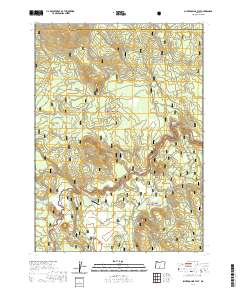
2020 Map of Silver Dollar Flat
USGS Topo · Published 2020About this map
Silver Dollar Flat and the headwaters of the Williamson River define this high-altitude landscape within the eastern reaches of the Winema National Forest. The area is characterized by a network of drainage flats and remote meadows, including Teddy Powers Meadow and the low-lying Cordelia Flat. Hydrological features are central to the terrain, with the Sycan Wild and Scenic River winding through the eastern portion of the sheet near the border of the Fremont National Forest. A rare sign of modern development in this wilderness is the Moondance Ranch Airport, located near Rock Spring. Smaller water sources like Bottle Spring, Godowa Spring, and the uniquely named Coyote Bucket provide critical points of interest for those tracing the historical movement of livestock or early travelers through this corner of Klamath County.
Find a feature on this map
26 named features on this map. Tap any name to fly to it.
Don’t see what you’re looking for? This feature index may not catch every label — zoom into the map to look around manually.
Map Details
Editions of this 2020 Silver Dollar Flat Map
This is the sole edition of this map. No revisions or reprints were ever made.
Other maps of this area

1889 · Klamath
USGS Topo · 1:250,000

1894 · Klamath
USGS Topo · 1:250,000

1955 · Klamath Falls
USGS Topo · 1:250,000

1958 · Klamath Falls
USGS Topo · 1:250,000

1960 · Riverbed Butte
USGS Topo · 1:62,500

1960 · Sycan Marsh
USGS Topo · 1:62,500

1960 · Fuego Mountain
USGS Topo · 1:62,500

1960 · Yamsay Mountain
USGS Topo · 1:62,500

1980 · Williamson River
USGS Topo · 1:100,000
1988 · Sycan Marsh West
USGS Topo · 1:24,000