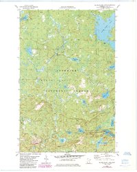
1981 Map of Silver Island Lake
USGS Topo · Published 1985About this map
Silver Island Lake anchors the northeastern corner of this terrain within the Superior National Forest, where a dense network of glacial lakes and waterways defines the landscape. The Dumbbell River meanders through the central portion of the quadrangle, connecting smaller water bodies like Folly Lake and Green Wing Lake. Several gravel pits indicate local resource extraction, while features such as the Picnic Area and Public Access points on Silver Island Lake and Section 29 Lake point to the area's role in public recreation during the early 1980s.
Find a feature on this map
27 named features on this map. Tap any name to fly to it.
Don’t see what you’re looking for? This feature index may not catch every label — zoom into the map to look around manually.
Map Details
Editions of this 1981 Silver Island Lake Map
2 editions found
Other maps of this area

1954 · Two Harbors
USGS Topo · 1:250,000

1955 · Isabella
USGS Topo · 1:62,500

1955 · Cramer
USGS Topo · 1:62,500

1957 · Two Harbors
USGS Topo · 1:250,000

1958 · Two Harbors
USGS Topo · 1:250,000

1960 · Kawishiwi Lake
USGS Topo · 1:24,000

1960 · Perent Lake
USGS Topo · 1:24,000

1964 · Two Harbors
USGS Topo · 1:250,000
1981 · Silver Island Lake
USGS Topo · 1:24,000
1981 · Cramer
USGS Topo · 1:24,000