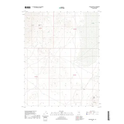
2018 Map of Silver King Well
USGS Topo · Published 2018About this map
Silver King Well sits as a vital water source in this high-desert landscape of Lincoln County, where the transition between major mountain systems defines the terrain. The western edge is anchored by the Egan Range, while the Schell Creek Range emerges in the southeast, creating a high-altitude corridor marked by Cave Valley and Piute Valley. This 2018 survey reveals a network of dispersed water points essential for life and livestock in the Great Basin, including Trough Spring at the head of Trough Spring Canyon, Horse Spring, and Wolf Hole Spring. The map documents the persistent importance of these named springs and wells in an arid environment, illustrating how localized water availability dictated the historical use of these basins between the jagged ridges of eastern Nevada.
Find a feature on this map
14 named features on this map. Tap any name to fly to it.
Don’t see what you’re looking for? This feature index may not catch every label — zoom into the map to look around manually.
Map Details
Editions of this 2018 Silver King Well Map
This is the sole edition of this map. No revisions or reprints were ever made.
Other maps of this area

1956 · Lund
USGS Topo · 1:250,000

1960 · Lund
USGS Topo · 1:250,000

1969 · Gap Mountain
USGS Topo · 1:24,000

1969 · Sunnyside
USGS Topo · 1:24,000

1971 · Sidehill Spring
USGS Topo · 1:24,000

1971 · Bailey Wash
USGS Topo · 1:24,000
1971 · Timber Mtn Pass NE
USGS Topo · 1:24,000

1971 · Cave Valley Well
USGS Topo · 1:24,000

1971 · Silver King Mtn
USGS Topo · 1:24,000

1971 · Sidehill Pass
USGS Topo · 1:24,000