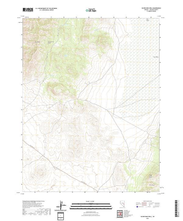
2021 Map of Silver King Well
USGS Topo · Published 2021About this map
The Egan Range dominates the western portion of this Lincoln County survey, giving way to the prominent Trough Spring Canyon. This high-desert landscape is defined by its critical water sources, including Trough Spring, Horse Spring, and Wolf Hole Spring, which likely served as vital landmarks for early travelers and cattlemen in this arid basin. To the east, the terrain opens into Cave Valley before rising again into the Schell Creek Range at the edge of the sheet. The presence of the Access Route Trl snaking through the southern sections indicates the modern navigational network that overlays this ancient topography. In the far south, the land descends toward Piute Valley, illustrating the classic basin-and-range geography of eastern Nevada.
Find a feature on this map
15 named features on this map. Tap any name to fly to it.
Don’t see what you’re looking for? This feature index may not catch every label — zoom into the map to look around manually.
Map Details
Editions of this 2021 Silver King Well Map
This is the sole edition of this map. No revisions or reprints were ever made.
Other maps of this area

1956 · Lund
USGS Topo · 1:250,000

1960 · Lund
USGS Topo · 1:250,000

1969 · Gap Mountain
USGS Topo · 1:24,000

1969 · Sunnyside
USGS Topo · 1:24,000

1971 · Sidehill Spring
USGS Topo · 1:24,000

1971 · Bailey Wash
USGS Topo · 1:24,000
1971 · Timber Mtn Pass NE
USGS Topo · 1:24,000

1971 · Cave Valley Well
USGS Topo · 1:24,000

1971 · Silver King Mtn
USGS Topo · 1:24,000

1971 · Sidehill Pass
USGS Topo · 1:24,000