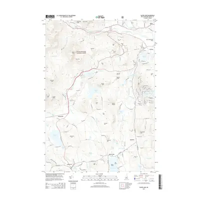
2015 Map of Silver Lake
USGS Topo · Published 2015About this map
Silver Lake serves as a central hub for the small communities and recreational landscapes south of the White Mountain National Forest in this 2015 study. The map illustrates a transition from the structured residential clusters near Madison and the Madison Cem to the rugged granite features of the Mount Washington Valley. To the north, the Swift River and Allard Brook drain through narrow valleys between prominent peaks like Sugarloaf and White Ledge. The presence of the Leavitt Airport and numerous named ledges, such as Whitton Ledge and Band M Ledge, reflects the region's character as a destination for both aviation and outdoor exploration. Along the western edge, the Chocorua River feeds into Chocorua Lake, while the eastern side is defined by the unique hydrology of Pea Porridge Pond and the Madison Boulder, a significant local geological landmark.
Find a feature on this map
133 named features on this map. Tap any name to fly to it.
Don’t see what you’re looking for? This feature index may not catch every label — zoom into the map to look around manually.
Map Details
Editions of this 2015 Silver Lake Map
This is the sole edition of this map. No revisions or reprints were ever made.
Other maps of this area

1894 · North Conway
USGS Topo · 1:62,500

1895 · Crawford Notch
USGS Topo · 1:62,500

1896 · Crawford Notch
USGS Topo · 1:62,500

1896 · North Conway
USGS Topo · 1:62,500

1930 · Ossipee Lake
USGS Topo · 1:62,500

1931 · Mt. Chocorua
USGS Topo · 1:62,500

1942 · North Conway
USGS Topo · 1:62,500

1945 · North Conway
USGS Topo · 1:62,500

1946 · Crawford Notch
USGS Topo · 1:62,500

1949 · Portland
USGS Topo · 1:250,000