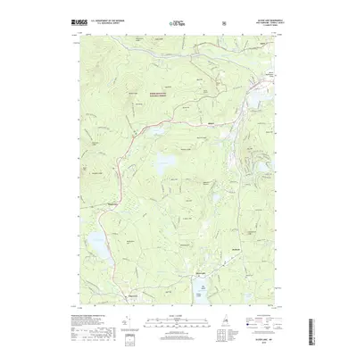
2018 Map of Silver Lake
USGS Topo · Published 2018About this map
White Mountain National Forest dominates the northwestern portion of this area, where high ridges like Sugarloaf and White Ledge descend into the corridor of the Swift River. The landscape is a network of water and granite, characterized by numerous lakes and ponds such as Iona Lake, Whitton Pond, and the large expanse of Silver Lake in the south. The village of Madison serves as a central hub, with the nearby Madison Boulder standing as a significant glacial landmark. To the south, the settlement of Chocorua sits along the Chocorua River, which drains the western slopes. Transportation is defined by routes like White Mountain Rd, which connects smaller communities including Albany and Pequawket to the Mount Washington Valley to the east. Local history is anchored by the Madison Cem and the Leavitt Airport, reflecting the region's balance of residential settlement and recreational aviation.
Find a feature on this map
153 named features on this map. Tap any name to fly to it.
Don’t see what you’re looking for? This feature index may not catch every label — zoom into the map to look around manually.
Map Details
Editions of this 2018 Silver Lake Map
This is the sole edition of this map. No revisions or reprints were ever made.
Other maps of this area

1894 · North Conway
USGS Topo · 1:62,500

1895 · Crawford Notch
USGS Topo · 1:62,500

1896 · Crawford Notch
USGS Topo · 1:62,500

1896 · North Conway
USGS Topo · 1:62,500

1930 · Ossipee Lake
USGS Topo · 1:62,500

1931 · Mt. Chocorua
USGS Topo · 1:62,500

1942 · North Conway
USGS Topo · 1:62,500

1945 · North Conway
USGS Topo · 1:62,500

1946 · Crawford Notch
USGS Topo · 1:62,500

1949 · Portland
USGS Topo · 1:250,000