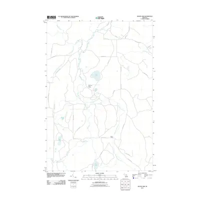
2011 Map of Silver Lake
USGS Topo · Published 2011About this map
The Black River and its various tributaries carve a winding path through this northern Michigan landscape, defining the local geography around Silver Lake. This 2011 survey reveals a region characterized by complex hydrography and a network of rural roads and trails, such as Shan-Gra-La Rd and Farmer Trl. Transportation in this area is largely defined by the river crossings, most notably the Barber Bridge over the East Branch Black River. The presence of the Black River Ranch Airport near Dollar Lake indicates the specialized land use in this corner of Otsego County. From the Blue Lakes in the southwest to the Oxbow Creek system in the northeast, the map provides a detailed view of the water resources and access routes, including Canada Creek Hwy and Old State Rd, that have supported the area's residents and visitors.
Find a feature on this map
35 named features on this map. Tap any name to fly to it.
Don’t see what you’re looking for? This feature index may not catch every label — zoom into the map to look around manually.
Map Details
Editions of this 2011 Silver Lake Map
This is the sole edition of this map. No revisions or reprints were ever made.
Other maps of this area

1954 · Hetherton
USGS Topo · 1:62,500

1955 · Atlanta
USGS Topo · 1:62,500

1955 · Cheboygan
USGS Topo · 1:250,000

1957 · Tower
USGS Topo · 1:62,500

1957 · Onaway
USGS Topo · 1:62,500

1958 · Cheboygan
USGS Topo · 1:250,000

1982 · Petoskey
USGS Topo · 1:100,000
1986 · Onaway
USGS Topo · 1:24,000

1986 · Silver Lake
USGS Topo · 1:24,000
1986 · Saunders Creek
USGS Topo · 1:24,000