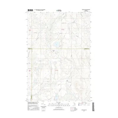
2017 Map of Silver Lake
USGS Topo · Published 2017About this map
The Black River and its multiple branches, including the E Br Black River, define this landscape at the intersection of Cheboygan, Otsego, and Montmorency counties. This 2017 survey details a remote wetland and forest environment characterized by numerous glacial lakes such as Silver Lake, Dollar Lake, and the Foch Lakes chain. The presence of the Black River Ranch Airport and the High Country Pathway suggests a region dedicated to conservation and seasonal recreation. Local transportation and topography are marked by features like Barber Bridge and the distinct depression of Mc Masters Hollow. The map also traces the Meridian Line Rd, reflecting the underlying structural history of the Public Land Survey System in Michigan's Lower Peninsula.
Find a feature on this map
42 named features on this map. Tap any name to fly to it.
Don’t see what you’re looking for? This feature index may not catch every label — zoom into the map to look around manually.
Map Details
Editions of this 2017 Silver Lake Map
This is the sole edition of this map. No revisions or reprints were ever made.
Other maps of this area

1954 · Hetherton
USGS Topo · 1:62,500

1955 · Atlanta
USGS Topo · 1:62,500

1955 · Cheboygan
USGS Topo · 1:250,000

1957 · Tower
USGS Topo · 1:62,500

1957 · Onaway
USGS Topo · 1:62,500

1958 · Cheboygan
USGS Topo · 1:250,000

1982 · Petoskey
USGS Topo · 1:100,000
1986 · Onaway
USGS Topo · 1:24,000

1986 · Silver Lake
USGS Topo · 1:24,000
1986 · Saunders Creek
USGS Topo · 1:24,000