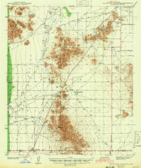
1942 Map of Silver Reef Mountains
USGS Topo · Published 1942About this map
Mining operations and Tohono O'odham settlements define this desert landscape within the Papago Indian Reservation. Surveyed shortly before the onset of World War II, the map documents a network of mineral extraction sites concentrated around the Silver Reef Mountains, including the Silver Reef Mine, Old Jonah Mine, and Jackrabbit Mine. These workings are interspersed with traditional villages like Vaiva Vo, Tat Momoli, and Gu Komelik, often situated near vital water sources such as Santa Rosa Wash.
Find a feature on this map
25 named features on this map. Tap any name to fly to it.
Don’t see what you’re looking for? This feature index may not catch every label — zoom into the map to look around manually.
Map Details
Editions of this 1942 Silver Reef Mountains Map
2 editions found
Other maps of this area

1922 · Casa Grande
USGS Topo · 1:62,500

1922 · Signal Peak
USGS Topo · 1:62,500

1924 · Signal Peak
USGS Topo · 1:62,500

1924 · Casa Grande
USGS Topo · 1:62,500

1934 · Silver Bell
USGS Topo · 1:125,000

1941 · Vekol Mountains
USGS Topo · 1:62,500

1942 · Silver Reef Mountains
USGS Topo · 1:62,500

1942 · Vekol Mountains
USGS Topo · 1:62,500

1946 · Antelope Peak
USGS Topo · 1:62,500

1947 · Eloy
USGS Topo · 1:62,500
Featured Places
- North Komelik, Sif Oidak District
- Sif Oidak District, AZ
- Tat Momoli, Sif Oidak District
- Shopishk, Sif Oidak District
- Vaiva Vo, Sif Oidak District