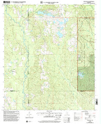
2000 Map of Silver Run
USGS Topo · Published 2002About this map
The Wolf River and Biloxi River drainage systems define this section of the Mississippi piney woods at the turn of the millennium. The landscape is characterized by its transition from the managed timberlands of the De Soto National Forest in the east to the scattered rural settlements of Silver Run and Barth further west. Genealogical interest is particularly high here, with several family-named landmarks including Head Cem, Ladner Cem, and Hickman Lookout Cem scattered across the undulating terrain.
Find a feature on this map
32 named features on this map. Tap any name to fly to it.
Don’t see what you’re looking for? This feature index may not catch every label — zoom into the map to look around manually.
Map Details
Editions of this 2000 Silver Run Map
This is the sole edition of this map. No revisions or reprints were ever made.
Other maps of this area

1947 · Wiggins
USGS Topo · 1:62,500

1949 · Wiggins
USGS Topo · 1:62,500

1953 · Mobile
USGS Topo · 1:250,000

1954 · McHenry
USGS Topo · 1:62,500

1955 · Savannah
USGS Topo · 1:62,500

1957 · Mobile
USGS Topo · 1:250,000

1958 · Carnes
USGS Topo · 1:62,500

1960 · Mobile
USGS Topo · 1:250,000

1963 · Mobile
USGS Topo · 1:250,000

1965 · Mobile
USGS Topo · 1:250,000