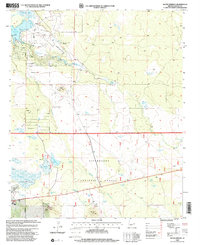
1998 Map of Silver Springs
USGS Topo · Published 2000About this map
Sitgreaves National Forest covers the southern expanse of this high-altitude landscape, where numerous livestock watering tanks and springs support the high-desert terrain. The northern section of the map reveals the residential and recreational development surrounding White Mountain Lake, which includes the White Mountain Lake Airport and the dedicated Landing Strip. The hydraulic complexity of the area is evident in the network of features like The Forebay, Duck Lake, and Silver Creek, which are managed for both agricultural and recreational use. Along Rocky Arroyo, a series of named tanks such as Underpass Tank and First Knoll Tank trace the movement of water through the forest. To the west, the infrastructure of the Show Low Municipal Airport and its Airport Tanks marks the encroaching City Boundary, contrasting with the more primitive tracks and cinder excavations like the Cinder Pit found further east near Cooley Knoll.
Find a feature on this map
44 named features on this map. Tap any name to fly to it.
Don’t see what you’re looking for? This feature index may not catch every label — zoom into the map to look around manually.
Map Details
Editions of this 1998 Silver Springs Map
This is the sole edition of this map. No revisions or reprints were ever made.
Other maps of this area

1886 · St Johns
USGS Topo · 1:250,000

1886 · Holbrook
USGS Topo · 1:250,000

1892 · St Johns
USGS Topo · 1:250,000

1893 · Holbrook
USGS Topo · 1:250,000

1954 · Holbrook
USGS Topo · 1:250,000

1954 · Saint Johns
USGS Topo · 1:250,000

1957 · Holbrook
USGS Topo · 1:250,000

1957 · Saint Johns
USGS Topo · 1:250,000

1958 · Saint Johns
USGS Topo · 1:250,000

1958 · Holbrook
USGS Topo · 1:250,000