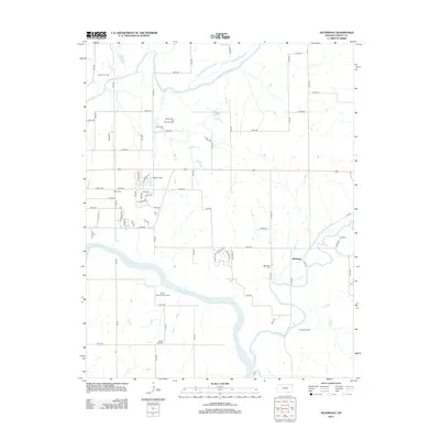
2012 Map of Silverdale
USGS Topo · Published 2012About this map
The Arkansas River and Walnut River converge in this corner of Cowley County, shaping a landscape defined by its waterways and energy resources. The Walnut Bend Oil and Gas Field and Larcom Oil Field underscore the industrial character of the region, where rural section lines and a grid of county roads connect scattered homesteads and recreational sites. Cultural landmarks such as Prairie View Christian Camp and Camp Ko-Ha-Me are positioned near the riverbanks, reflecting the area's use for community gathering and outdoor activities.
Find a feature on this map
70 named features on this map. Tap any name to fly to it.
Don’t see what you’re looking for? This feature index may not catch every label — zoom into the map to look around manually.
Map Details
Editions of this 2012 Silverdale Map
This is the sole edition of this map. No revisions or reprints were ever made.
Other maps of this area

1889 · Burden
USGS Topo · 1:125,000

1890 · Wellington
USGS Topo · 1:125,000

1935 · Kaw
USGS Topo · 1:62,500

1955 · Wichita
USGS Topo · 1:250,000

1955 · Enid
USGS Topo · 1:250,000

1958 · Enid
USGS Topo · 1:250,000

1958 · Wichita
USGS Topo · 1:250,000

1963 · Kaw City NW
USGS Topo · 1:24,000
1964 · Hardy
USGS Topo · 1:24,000
1964 · Maple City
USGS Topo · 1:24,000