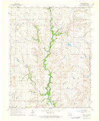
1964 Map of Hardy
USGS Topo · Published 1965About this map
The small settlement of Hardy sits at the intersection of several drainages in northern Oklahoma, just south of the Kansas Oklahoma state line. This 1964 survey captures the landscape as it transitions into the Osage Indian Reservation Boundary to the east, marked by a complex network of creeks including Little Beaver Creek, Canadian Creek, and Rabbit Creek. The terrain is defined by the winding course of the Midland Valley, which cuts through the region alongside Mud Creek and Myers Creek.
Find a feature on this map
17 named features on this map. Tap any name to fly to it.
Don’t see what you’re looking for? This feature index may not catch every label — zoom into the map to look around manually.
Map Details
Editions of this 1964 Hardy Map
2 editions found
Other maps of this area

1889 · Burden
USGS Topo · 1:125,000

1916 · Foraker
USGS Topo · 1:62,500

1935 · Kaw
USGS Topo · 1:62,500

1955 · Wichita
USGS Topo · 1:250,000

1955 · Enid
USGS Topo · 1:250,000

1958 · Enid
USGS Topo · 1:250,000

1958 · Wichita
USGS Topo · 1:250,000

1962 · Dexter SW
USGS Topo · 1:24,000

1963 · Uncas
USGS Topo · 1:24,000

1963 · Kaw City NW
USGS Topo · 1:24,000