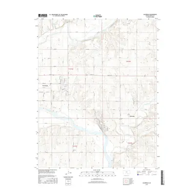
2015 Map of Silverdale
USGS Topo · Published 2015About this map
The Arkansas River and Walnut River converge in this southeastern Kansas landscape, shaping a terrain defined by significant river bends and drainage networks. The settlement of Parkerfield sits in the northwest near the Walnut, while Silverdale is positioned further east above the Grouse Creek valley. These waterways are flanked by distinctive landmarks such as Cardiac Hill and the Horizon Ridge Line, which overlook the expansive River Bottom.
Find a feature on this map
40 named features on this map. Tap any name to fly to it.
Don’t see what you’re looking for? This feature index may not catch every label — zoom into the map to look around manually.
Map Details
Editions of this 2015 Silverdale Map
This is the sole edition of this map. No revisions or reprints were ever made.
Other maps of this area

1889 · Burden
USGS Topo · 1:125,000

1890 · Wellington
USGS Topo · 1:125,000

1935 · Kaw
USGS Topo · 1:62,500

1955 · Wichita
USGS Topo · 1:250,000

1955 · Enid
USGS Topo · 1:250,000

1958 · Enid
USGS Topo · 1:250,000

1958 · Wichita
USGS Topo · 1:250,000

1963 · Kaw City NW
USGS Topo · 1:24,000
1964 · Hardy
USGS Topo · 1:24,000
1964 · Maple City
USGS Topo · 1:24,000