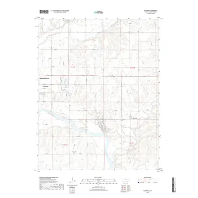
2018 Map of Silverdale
USGS Topo · Published 2018About this map
The confluence of the Walnut River and the Arkansas River defines the landscape of southeastern Cowley County, just east of Arkansas City. This 2018 survey reveals a terrain of low bluffs and river bottoms, characterized by the prominent elevation at Cardiac Hill overlooking the Arkansas River. The settlement pattern is largely rural, anchored by the small communities of Parkerfield and Silverdale. Longstanding local history is preserved through the locations of several burial grounds, including Parker Cem, Silverdale Cem, and Springside Cem. Transportation across the river valleys is facilitated by a network of county roads like Co Rd 12 and Co Rd 22, while local landmarks such as Munson Field and Lake Wynds provide modern points of interest. Eastward, Grouse Creek and Otter Cr cut through the hills, illustrating the natural drainage system of the Kansas plains.
Find a feature on this map
49 named features on this map. Tap any name to fly to it.
Don’t see what you’re looking for? This feature index may not catch every label — zoom into the map to look around manually.
Map Details
Editions of this 2018 Silverdale Map
This is the sole edition of this map. No revisions or reprints were ever made.
Other maps of this area

1889 · Burden
USGS Topo · 1:125,000

1890 · Wellington
USGS Topo · 1:125,000

1935 · Kaw
USGS Topo · 1:62,500

1955 · Wichita
USGS Topo · 1:250,000

1955 · Enid
USGS Topo · 1:250,000

1958 · Enid
USGS Topo · 1:250,000

1958 · Wichita
USGS Topo · 1:250,000

1963 · Kaw City NW
USGS Topo · 1:24,000
1964 · Hardy
USGS Topo · 1:24,000
1964 · Maple City
USGS Topo · 1:24,000