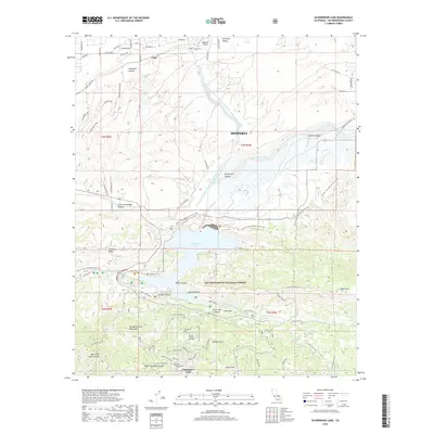
2018 Map of Silverwood Lake
USGS Topo · Published 2018About this map
Silverwood Lake serves as the focal point of this 2018 survey, where the infrastructure of the Governor Edmund G Brown East Branch California Aqueduct meets the southern edge of the Hesperia high desert. The map captures the sharp transition from the residential development around Lugo and the Hesperia Airport to the steep, protected terrain of the San Bernardino National Forest. Outdoor recreational history is well-documented here, with the Pacific Crest National Scenic Trail winding through the complex topography of Cleghorn Ridge and Sawpit Canyon. To the south, the mountain community of Cedarpines Park sits at the edge of the San Bernardino Mountains, surrounded by named peaks and overlooks like Jamajab Point, Pillars of God, and Breezy Point, providing a detailed look at the interface between San Bernardino County's growing desert cities and its forest wilderness.
Find a feature on this map
81 named features on this map. Tap any name to fly to it.
Don’t see what you’re looking for? This feature index may not catch every label — zoom into the map to look around manually.
Map Details
Editions of this 2018 Silverwood Lake Map
This is the sole edition of this map. No revisions or reprints were ever made.
Other maps of this area

1896 · San Bernardino
USGS Topo · 1:62,500

1898 · San Bernardino
USGS Topo · 1:62,500

1899 · Redlands
USGS Topo · 1:62,500

1901 · Southern California Sheet No. 1
USGS Topo · 1:250,000

1901 · San Bernardino
USGS Topo · 1:62,500

1901 · Redlands
USGS Topo · 1:62,500

1902 · Deep Creek
USGS Topo · 1:62,500

1902 · Hesperia
USGS Topo · 1:62,500

1904 · Southern California Sheet No. 1
USGS Topo · 1:250,000

1936 · Devore
USGS Topo · 1:31,680