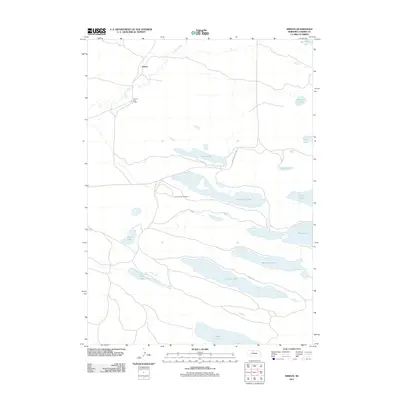
2011 Map of Simeon
USGS Topo · Published 2011About this map
The settlement of Simeon and the Simeon Post Office define the human footprint on this northern Nebraska landscape, situated near the headwaters of Gordon Creek. This region is characterized by a high concentration of elongated water bodies and wetlands, including Pelican Lake, Hackberry Lake, and Dads Lake. The map reveals a specific infrastructure for land management and conservation, notably Lookout Tower Number 1 and the winding Refuge Rd, which provides access through the lake-studded terrain. The drainage patterns of Gordon Creek and the orientation of lakes like Long Lake and Whitewater Lake suggest the unique sandy topography and hydrological character of this part of Cherry County. Remote and sparsely populated, the area is connected to the wider state via State Hwy Spur 16B, emphasizing its role as a specialized destination for resource management and natural study.
Find a feature on this map
19 named features on this map. Tap any name to fly to it.
Don’t see what you’re looking for? This feature index may not catch every label — zoom into the map to look around manually.
Map Details
Editions of this 2011 Simeon Map
This is the sole edition of this map. No revisions or reprints were ever made.
Other maps of this area

1950 · Simeon
USGS Topo · 1:62,500

1950 · Kennedy
USGS Topo · 1:62,500

1951 · Bull Lake
USGS Topo · 1:62,500

1951 · Brownlee
USGS Topo · 1:62,500

1957 · Valentine
USGS Topo · 1:250,000

1959 · Valentine
USGS Topo · 1:250,000

1985 · Goose Creek
USGS Topo · 1:100,000

1985 · Valentine
USGS Topo · 1:100,000
1985 · Snake River Falls
USGS Topo · 1:24,000
1985 · Kennedy
USGS Topo · 1:24,000