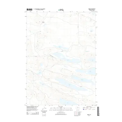
2014 Map of Simeon
USGS Topo · Published 2014About this map
Simeon and the surrounding Sandhills of Cherry County are defined by a complex network of freshwater bodies and marshlands. The landscape is characterized by its numerous elongated lakes, including Pelican Lake, Hackberry Lake, and Whitewater Lake, which are interconnected by primitive tracks and controlled access routes like Refuge Rd. This 2014 survey documents the hydraulic pattern of the region, where Gordon Cr flows through the northern reaches near the Simeon settlement site. The map highlights the intersection of conservation and recreation, evidenced by the CCC Fire Tower Trail, a reminder of the Civilian Conservation Corps' historical presence in managing these plains. From the larger waters of Big Alkali Lake to the secluded Dads Lake, this document provides a precise record of the shoreline configurations and elevations within this unique Nebraska wetland system.
Find a feature on this map
17 named features on this map. Tap any name to fly to it.
Don’t see what you’re looking for? This feature index may not catch every label — zoom into the map to look around manually.
Map Details
Editions of this 2014 Simeon Map
This is the sole edition of this map. No revisions or reprints were ever made.
Other maps of this area

1950 · Simeon
USGS Topo · 1:62,500

1950 · Kennedy
USGS Topo · 1:62,500

1951 · Bull Lake
USGS Topo · 1:62,500

1951 · Brownlee
USGS Topo · 1:62,500

1957 · Valentine
USGS Topo · 1:250,000

1959 · Valentine
USGS Topo · 1:250,000

1985 · Goose Creek
USGS Topo · 1:100,000

1985 · Valentine
USGS Topo · 1:100,000
1985 · Snake River Falls
USGS Topo · 1:24,000
1985 · Kennedy
USGS Topo · 1:24,000