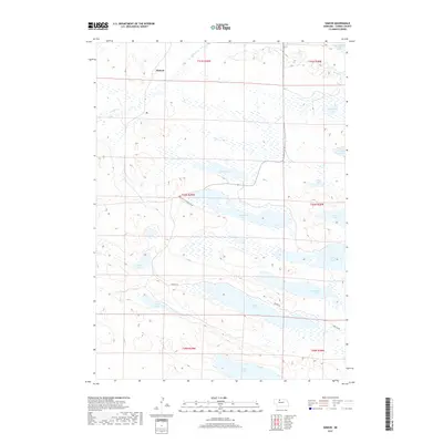
2017 Map of Simeon
USGS Topo · Published 2017About this map
Simeon and the surrounding Sandhills of Cherry County are defined by a complex network of wetlands and freshwater lakes in this 2017 study. The area is characterized by massive bodies of water such as Pelican Lake, Hackberry Lake, and Dewey Lake, which dominate the central and southern portions of the landscape. These water bodies are interspersed with smaller features like Watts Lake and Duck Lake, creating a unique hydrological environment.
Find a feature on this map
23 named features on this map. Tap any name to fly to it.
Don’t see what you’re looking for? This feature index may not catch every label — zoom into the map to look around manually.
Map Details
Editions of this 2017 Simeon Map
This is the sole edition of this map. No revisions or reprints were ever made.
Other maps of this area

1950 · Simeon
USGS Topo · 1:62,500

1950 · Kennedy
USGS Topo · 1:62,500

1951 · Bull Lake
USGS Topo · 1:62,500

1951 · Brownlee
USGS Topo · 1:62,500

1957 · Valentine
USGS Topo · 1:250,000

1959 · Valentine
USGS Topo · 1:250,000

1985 · Goose Creek
USGS Topo · 1:100,000

1985 · Valentine
USGS Topo · 1:100,000
1985 · Snake River Falls
USGS Topo · 1:24,000
1985 · Kennedy
USGS Topo · 1:24,000