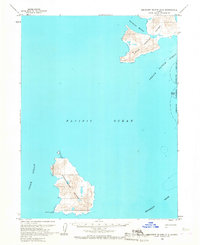
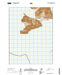
1963 Map of Simeonof Island D-2
USGS Topo · Published 1967About this map
Chernabura Island and Little Koniuji Island dominate this mid-century topographic study of the Shumagin Islands in the Pacific Ocean. The map documents the intricate coastline and elevation of these remote landmasses, including the southern tip of Chernabura at Point Farewell. The survey reflects a period when the United States was refining its coastal knowledge of Alaska through photogrammetric methods and earlier hydrographic charts. Significant marine passages are recorded, such as the Otter Strait to the west and the expansive Twelve Fathom Strait separating the islands. A portion of the Simeonof National Wildlife Refuge is identified along the eastern boundary, encompassing the Murie Islets. The lack of inland structures or roads emphasizes the uninhabited, maritime nature of the Shumagin group, with the Shumagin Bank shelf extending into the surrounding waters.
Find a feature on this map
10 named features on this map. Tap any name to fly to it.
Don’t see what you’re looking for? This feature index may not catch every label — zoom into the map to look around manually.
Map Details
Editions of this 1963 Simeonof Island D-2 Map
This is the sole edition of this map. No revisions or reprints were ever made.
Other maps of this area

1951 · Stepovak Bay
USGS Topo · 1:250,000

1963 · Simeonof Island D-1
USGS Topo · 1:63,360
1963 · Simeonof Island D-3
USGS Topo · 1:63,360
1963 · Stepovak Bay A-6
USGS Topo · 1:63,360
1963 · Stepovak Bay A-5
USGS Topo · 1:63,360

1963 · Simeonof Island
USGS Topo · 1:250,000

1963 · Stepovak Bay
USGS Topo · 1:250,000

1967 · Simeonof Island
USGS Topo · 1:250,000

1969 · Stepovak Bay
USGS Topo · 1:250,000
2020 · Simeonof Island D-2 NE
USGS Topo · 1:25,000