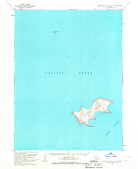
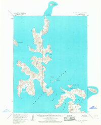
1963 Map of Simeonof Island D-3
USGS Topo · Published 1967About this map
Bird Island rises from the cold waters of the Pacific Ocean in this mid-century survey of the Shumagin Islands area. The map, based on 1962 aerial photography, provides a detailed topographic record of this isolated landmass, reaching its southern terminus at Point Welcome. To the southeast, the depths of Otter Strait separate the island from its neighbors, while the small outcroppings known as the Twins stand alone to the north. This document reflects a period of intensive photogrammetric mapping by the Geological Survey and USC&GS, capturing the exact contours and shoreline of these remote Alaskan features before later environmental changes. It is a precise record of maritime geography, primarily defined by high-elevation ridges and the stark separation of the strait.
Find a feature on this map
5 named features on this map. Tap any name to fly to it.
Don’t see what you’re looking for? This feature index may not catch every label — zoom into the map to look around manually.
Map Details
Editions of this 1963 Simeonof Island D-3 Map
This is the sole edition of this map. No revisions or reprints were ever made.
Other maps of this area

1951 · Stepovak Bay
USGS Topo · 1:250,000

1953 · Port Moller
USGS Topo · 1:250,000

1963 · Port Moller A-1
USGS Topo · 1:63,360
1963 · Simeonof Island D-2
USGS Topo · 1:63,360
1963 · Stepovak Bay A-6
USGS Topo · 1:63,360
1963 · Simeonof Island D-4
USGS Topo · 1:63,360
1963 · Stepovak Bay A-5
USGS Topo · 1:63,360

1963 · Simeonof Island
USGS Topo · 1:250,000

1963 · Stepovak Bay
USGS Topo · 1:250,000

1967 · Simeonof Island
USGS Topo · 1:250,000