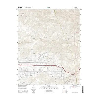
2015 Map of Simi Valley East
USGS Topo · Published 2015About this map
Simi Valley occupies the broad floor of this landscape, flanked by the steep ridgelines of Big Mtn and Oak Ridge. The 2015 survey reveals the modern suburban footprint of Santa Susana and Santa Susana Knolls as they interface with a complex network of canyons. The rugged eastern boundary is defined by the Ventura County and Los Angeles County line, crossing through significant terrain like Rocky Peak and the Santa Susana Pass.
Find a feature on this map
39 named features on this map. Tap any name to fly to it.
Don’t see what you’re looking for? This feature index may not catch every label — zoom into the map to look around manually.
Map Details
Editions of this 2015 Simi Valley East Map
This is the sole edition of this map. No revisions or reprints were ever made.
Other maps of this area

1900 · Triunfo Pass
USGS Topo · 1:62,500

1900 · Piru
USGS Topo · 1:62,500

1903 · Calabasas
USGS Topo · 1:62,500

1903 · Camulos
USGS Topo · 1:125,000

1903 · Santa Susana
USGS Topo · 1:62,500

1921 · Piru
USGS Topo · 1:62,500

1921 · Triunfo Pass
USGS Topo · 1:62,500

1925 · Chatsworth
USGS Topo · 1:24,000

1927 · Chatsworth
USGS Topo · 1:24,000
1929 · Chatsworth
USGS Topo · 1:24,000
Featured Places
- Los Angeles, CA
- Simi Valley, CA
- Unincorporated Chatsworth, CA
- Santa Susana, CA
- Alamo Villas, Simi Valley