
1953 Map of Simpson
USGS Topo · Published 1954About this map
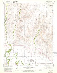
The Solomon River winds through the southern portion of this landscape, its broad floodplains and oxbows defining the geography near the small settlements of Asherville and Simpson. This 1953 survey captures the area during a period of transition, noting a significant section of road marked as Under Construction slicing across the center of the sheet, signaling the expansion of the regional highway network. The Union Pacific railroad tracks parallel the river, serving as the primary industrial artery for the rural communities and several scattered Sand Pits. Local genealogy is well-represented through family and community landmarks such as Mcbride Cem, West Asher Cem, and Asherville Cem. The terrain is deeply dissected by numerous waterways, including West Asher Creek, Asher Creek, and Lost Creek, which drain the uplands of Lulu and Asherville townships.
Find a feature on this map
24 named features on this map. Tap any name to fly to it.
Don’t see what you’re looking for? This feature index may not catch every label — zoom into the map to look around manually.
Map Details
Editions of this 1953 Simpson Map
2 editions found
Other maps of this area

1892 · Concordia
USGS Topo · 1:125,000

1892 · Minneapolis
USGS Topo · 1:125,000

1894 · Mankato
USGS Topo · 1:125,000

1894 · Beloit
USGS Topo · 1:125,000

1952 · Glasco SW
USGS Topo · 1:24,000

1952 · Glasco
USGS Topo · 1:24,000

1953 · Glasco NE
USGS Topo · 1:24,000

1953 · Beloit
USGS Topo · 1:24,000

1955 · Manhattan
USGS Topo · 1:250,000

1955 · Beloit
USGS Topo · 1:250,000