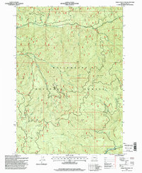
1997 Map of Sinker Mountain
USGS Topo · Published 1998About this map
Willamette National Forest encompasses this high-elevation terrain in Lane County, dominated by the prominent peaks of Sinker Mountain and Gold Point. The landscape is defined by the sharp descent of numerous drainages including Fall Creek, Portland Creek, and Christy Creek, which ultimately feed into the Middle Fork Willamette River at the southern edge of the quadrangle. This 1990s survey shows a landscape managed for both recreation and resource extraction, evidenced by the presence of several quarries alongside the isolated Elk Camp Shelter.
Find a feature on this map
31 named features on this map. Tap any name to fly to it.
Don’t see what you’re looking for? This feature index may not catch every label — zoom into the map to look around manually.
Map Details
Editions of this 1997 Sinker Mountain Map
This is the sole edition of this map. No revisions or reprints were ever made.
Other maps of this area

1925 · Waldo Lake
USGS Topo · 1:125,000

1934 · Mc Kenzie Bridge
USGS Topo · 1:96,000

1935 · Lowell
USGS Topo · 1:96,000

1940 · Mc Kenzie Bridge
USGS Topo · 1:125,000

1942 · Lowell
USGS Topo · 1:125,000

1951 · Leaburg
USGS Topo · 1:62,500

1953 · Salem
USGS Topo · 1:250,000

1954 · Salem
USGS Topo · 1:250,000

1955 · Hardesty Mtn
USGS Topo · 1:62,500

1955 · Blue River
USGS Topo · 1:62,500